
official data (NOAA/NHC Intermediate Public Advisory 12A + Forecast/Advisory 12 + Public Advisory 9 peak) · press triangulation (BBC)
Hurricane Polo: Cat-5 peak at 180 mph Tuesday — still Cat 4 off SW Mexico Wednesday
NOAA Hurricane Hunters and NHC Advisory 9 stamped Hurricane Polo as an extremely dangerous Category 5 with 180 mph sustained winds and 892 mb pressure on Tuesday; by Wednesday afternoon Intermediate Advisory 12A had Polo downgraded to Category 4 at 145 mph — still a very powerful major hurricane skirting southwestern Mexico with life-threatening flooding and mudslide risk, while President Claudia Sheinbaum said no direct landfall was expected.
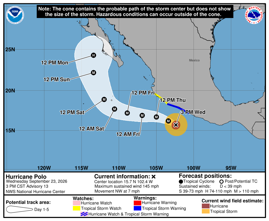
Key facts
- Peak stamp (Adv 9, 2100 UTC Tue Sep 22)
- Cat 5 · 180 mph (285 km/h) · 892 mb · 14.6N 101.5W · Hurricane Hunter–based
- Live stamp (Intermediate Adv 12A, 1800 UTC Wed Sep 23)
- Cat 4 · 145 mph (230 km/h) · 931 mb · 15.6N 102.1W · ~150 mi SSW Zihuatanejo · NW 5 mph
- Prior full Adv 12 (1500 UTC)
- 130 kt / gusts 160 · 927 mb · 15.4N 101.8W
- Watches/warnings
- TS Warning Tecpan de Galeana to Punta San Telmo; TS Watch west of Punta San Telmo to Playa Perula
- Rainfall hazard
- 4–6 in coastal Guerrero (isolated 8); 2–4 in Michoacán/Colima/Jalisco — life-threatening flooding/mudslides
- Track
- Core near SW Mexico coast next 1–2 days; forecast remain offshore (NHC)
- Sheinbaum (BBC)
- No direct landfall expected; vigilance Jalisco / Colima / Michoacán
- BBC intensity arc
- Downgraded Cat 5 → Cat 4 Wed morning; Hurricane Hunter Tue ~180 mph; still very powerful
- NOT current Cat 5
- Live NHC stamp is Category 4 — Cat 5 is Tuesday peak history only
- Live later
- Next NHC complete advisory / track change / flood reports → HUD — no invented landfall or death toll
Polo is a category 4 hurricane on the Saffir-Simpson Hurricane Wind Scale.
NHC Intermediate Public Advisory Number 12A · 1800 UTC Wed Sep 23 2026
Note
On Tuesday afternoon, the National Hurricane Center’s Advisory 9 stamped Hurricane Polo Category 5: 180 mph sustained winds, 892 millibars, an NOAA Hurricane Hunter fix south of Zihuatanejo. The bulletin called it an extremely dangerous Category 5 expected to stay that way for a couple of days.
By Wednesday afternoon, Intermediate Public Advisory 12A had stepped Polo down to Category 4 — 145 mph, 931 mb — centered near 15.6 north, 102.1 west, about 150 miles south-southwest of Zihuatanejo and drifting northwest at 5 mph. NHC still calls it a very powerful major hurricane. Tropical storm warnings cover Tecpan de Galeana to Punta San Telmo; a watch runs west to Playa Perula. Forecast rainfall is 4 to 6 inches along coastal Guerrero, isolated 8, and 2 to 4 inches into Michoacán, Colima, and Jalisco — with life-threatening flooding and mudslides in steep terrain. The core is expected near the southwestern Mexico coast for the next day or two but forecast to remain offshore. Mexico’s President Claudia Sheinbaum said Tuesday that information so far pointed to no direct landfall, while urging vigilance in Jalisco, Colima, and Michoacán. Next full NHC advisory and any track change stay on the HUD.
Why it matters
A storm that leapt to Category 5 at 180 mph and 892 mb on Tuesday is still a major Category 4 off a populated Mexican coast Wednesday — intensity history plus flood and mudslide risk, not a carnival landfall call. Official track keeps the core offshore; the rain bands do not.
Sources
- NHC Intermediate Public Advisory 12A / live TCPEP2
- NHC Forecast/Advisory 12
- NHC Public Advisory 9 (Cat-5 peak)
- BBC
Official NHC advisories. Live intensity/track → HUD / next advisory.