
official data (NOAA / NHC Remnants of Polo Public Advisory 38 + Discussion 38 + Forecast/Advisory 38, 0300 UTC Wed Sep 30 / 800 PM MST Tue Sep 29 2026 — last advisory) · supersedes boarded Adv 27 card
Polo dissipates over northwestern Mexico — NHC issues its last advisory
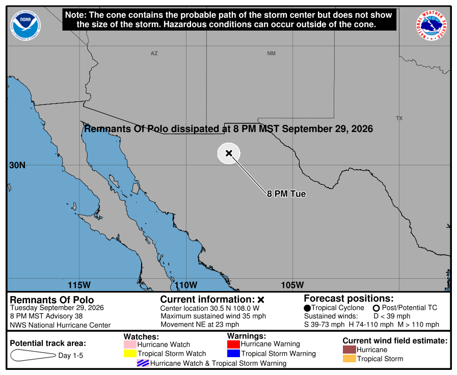
The National Hurricane Center’s Advisory 38 at 800 PM MST Tuesday says the remnants of Polo have dissipated over northwestern Mexico near 30.5 north, 108.0 west — about 245 miles northeast of Guaymas — with sustained winds near 35 mph and a pressure of 996 mb. No coastal watches or warnings remain, a Wind Advisory is still up for portions of southern New Mexico and far western Texas, and NHC says this is its last public advisory on a storm that peaked at Category 5, crossed Baja California Sur as a major hurricane and made a second landfall just east of Guaymas.
Key facts
- Adv 38 stamp (800 PM MST Tue Sep 29 / 0300 UTC Wed Sep 30)
- Remnants of Polo · 30.5N 108.0W · ~245 mi (395 km) NE of Guaymas · 35 mph (55 km/h) · 996 mb · NE (40°) at 23 mph
- Headline (Adv 38)
- …POLO DISSIPATES OVER NORTHWESTERN MEXICO…
- Watches / warnings
- No coastal watches or warnings in effect
- Wind (Adv 38)
- A Wind Advisory remains in effect for portions of southern New Mexico and far western Texas, where strong gusty winds are possible tonight with Polo’s remnants — local NWS offices carry the details
- Discussion 38
- Satellite images and surface observations indicate Polo dissipated over the rugged terrain of northwestern Mexico; the remnants are still producing areas of heavy rain and gusty winds over northwestern Mexico and the southwestern U.S.; initial intensity ~30 kt
- Rain outlook (Discussion 38)
- Remnant trough forecast to keep weakening; its moisture will likely produce heavy rainfall and flooding across the Southwest U.S. and the Southern High Plains Tuesday night and Wednesday morning
- Forecast/Advisory 38
- Remnant center near 30.5N 108.0W at 30/0300Z (30.0N 108.5W at 30/0000Z) · 30 kt, gusts 40 kt · forecast valid 30/1200Z: dissipated · last forecast/advisory on this system
- Last advisory
- “This is the last public advisory issued by the National Hurricane Center on Polo.”
- Adv 37 (200 PM MST Tue)
- Weakened to a tropical storm farther inland · 29.0N 109.7W · ~100 mi NE of Guaymas · 65 mph · 992 mb · Mexico discontinued all coastal watches and warnings · 4–6 in of rain (isolated 8) across southern and central Sonora — life-threatening flooding and mudslides possible
- Landfall near Guaymas (Intermediate 36A, 1100 AM MST Tue)
- “Polo makes landfall a little east of Guaymas Mexico” · center 28.0N 110.6W · ~20 mi E of Guaymas · 75 mph · 984 mb · NE 17 mph
- Baja California Sur (Adv 34, 800 PM MST Mon)
- “Polo about to make landfall in Baja California Sur” · 25.9N 112.5W · 115 mph · 963 mb — major-hurricane strength
- Peak (earlier cards)
- Category 5 over the Eastern Pacific — boarded Sep 24 (Adv 14, 160 mph) and Sep 26 (Adv 23) stamps; those pages stay in the archive
- Supersedes
- The Adv 27 Cat 3 Baja-warning card — off the board; its page stays live in the archive
- Live later
- Local NWS Wind Advisory and flash-flood products · WPC rainfall · any official Mexico damage or casualty figures → HUD. No further NHC advisories on Polo; no invented toll
…POLO DISSIPATES OVER NORTHWESTERN MEXICO… This is the last public advisory issued by the National Hurricane Center on Polo.
NHC Remnants of Polo Public Advisory Number 38 · 800 PM MST Tue Sep 29 2026
Note
National Hurricane Center Advisory 38, issued at 800 PM MST on Tuesday, September 29, closes the Polo file. The remnants were near 30.5 north, 108.0 west — about 245 miles northeast of Guaymas — with maximum sustained winds near 35 mph, a pressure of 996 millibars, moving northeast at 23 mph. No coastal watches or warnings remain. A Wind Advisory stays in effect for portions of southern New Mexico and far western Texas for strong gusty winds from the remnants, and NHC says this is its last public advisory on the system.
Discussion 38 says satellite images and surface observations show Polo dissipated over the rugged terrain of northwestern Mexico, but the remnants were still producing heavy rain and gusty winds over northwestern Mexico and the southwestern United States. Its moisture will likely bring heavy rainfall and flooding to the Southwest and the Southern High Plains Tuesday night and Wednesday morning. The forecast/advisory takes the system to dissipated by 1200 UTC Wednesday.
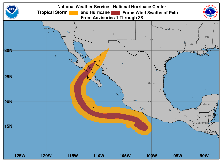
The official products trace the arc. Polo peaked at Category 5 over the Eastern Pacific. Advisory 34 on Monday night had it about to make landfall in Baja California Sur at 115 mph. Intermediate Advisory 36A on Tuesday morning put a second landfall a little east of Guaymas at 75 mph, and Advisory 37 had it down to a 65 mph tropical storm farther inland, with 4 to 6 inches of rain forecast over southern and central Sonora. This supersedes the Advisory 27 card; that page and the earlier Category 5 cards stay live in the archive. Local wind and flood products, and any official damage or casualty figures from Mexico, go to the HUD.
Why it matters
Category 5 over open water, a major hurricane at the Baja California Sur coast Monday night, still a hurricane at the Sonora coast Tuesday morning — and by Tuesday night the National Hurricane Center closed the file. Remnants only, last advisory, a Wind Advisory still up for southern New Mexico and far western Texas and flood-producing moisture over the Southwest. The official end of the sequence, not a damage count.
Sources
- NOAA National Hurricane Center
- NHC Discussion 38
- NHC Forecast/Advisory 38
- NHC Public Advisory 37 (weakens to a tropical storm inland)
- NHC Discussion 37
- NHC Intermediate Advisory 36A (landfall east of Guaymas)
- NHC Public Advisory 34 (about to make landfall in Baja California Sur)
- NHC Polo graphics archive (5-day cone, wind history)
- NHC EP172026 archive
- Superseded Adv 27 card (archive)
- Earlier Adv 23 Cat 5 card, Sep 26 (archive)
Primary + secondary attribution as listed. Live values go to the HUD / source product.