
official data
NASA EO: three-quarters of Puerto Rico in drought — 44% extreme
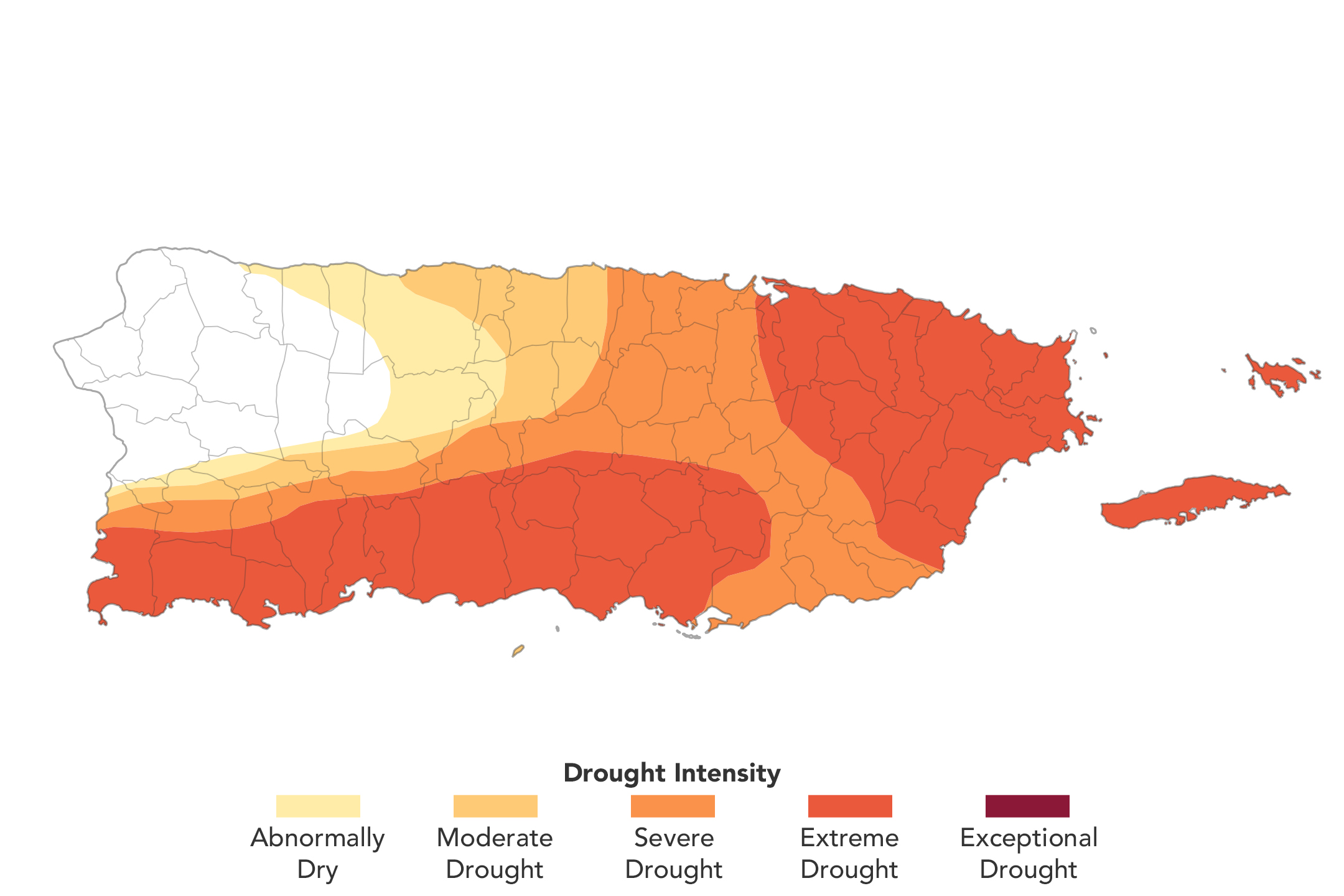
NASA Earth Observatory’s Image of the Day for 2 September 2026, “Drought Intensifies Across Puerto Rico” (story by Lindsey Doermann; map by Michala Garrison using U.S. Drought Monitor data), reports that as of the August 25, 2026 U.S. Drought Monitor assessment, three-quarters of Puerto Rico was experiencing at least moderate drought, and zones of extreme drought in the eastern and southwestern main island had expanded to cover 44 percent of the territory. Three months earlier, no part of Puerto Rico was in drought and less than 20 percent was abnormally dry. NIDIS context on the page notes that from mid-May through mid-July most of Puerto Rico received less than 60 percent of normal precipitation, with southern and southwestern areas under 20 percent of normal (a 3–6 inch / 76–152 mm deficit); San Juan had one of its warmest Julys on record; and Rio Fajardo streamflow reached record lows. The Puerto Rico governor declared a state of emergency in late July, and the U.S. government issued a drought disaster declaration for more than two dozen cities and towns in late August.
Key facts
- IOTD date
- Sep 2, 2026 (NASA Earth Observatory; story Lindsey Doermann; map Michala Garrison using USDM data)
- USDM Aug 25
- Three-quarters of Puerto Rico in at least moderate drought; extreme drought covers 44% of the territory
- Three months earlier
- No part of Puerto Rico in drought; <20% abnormally dry
- Precip / streamflow
- Mid-May–mid-July: most of PR <60% of normal precip; south/southwest <20% (3–6 in / 76–152 mm deficit); Rio Fajardo record lows; San Juan among warmest Julys on record
- Declarations
- PR governor emergency late July; U.S. drought disaster declaration for >24 cities/towns late August
- NASA map authors
- David Mocko (Goddard) and Jonathan Case (Marshall) first NASA authors of weekly USDM maps; Mocko authored Aug 18, 2026 update
As of August 25, 2026, three-quarters of Puerto Rico was experiencing at least moderate drought, according to the group’s assessment. Zones of extreme drought … had expanded in the previous week to cover 44 percent of the territory.
NASA Earth Observatory, Sep 2, 2026
Note
Official product: NASA Earth Observatory Image of the Day, 2 September 2026. Drought percentages and declaration language are from that page and the cited U.S. Drought Monitor / NIDIS context. Doom Signals does not invent drought categories beyond those figures.
- Official product: NASA EO Image of the Day, Sep 2, 2026
- Data: U.S. Drought Monitor assessment of Aug 25, 2026
- Place: Puerto Rico, United States
Why it matters
Fresh Sep 2 NASA EO Image of the Day with official USDM August 25 statistics (75% ≥ moderate; 44% extreme) and named emergency/disaster declarations — a sourced Caribbean drought signal for the climate rail, not a panic headline.
Sources
Official data. Not a forecast.