
official data
Borneo choked in smoke — NOAA-20 VIIRS spies Kalimantan blaze
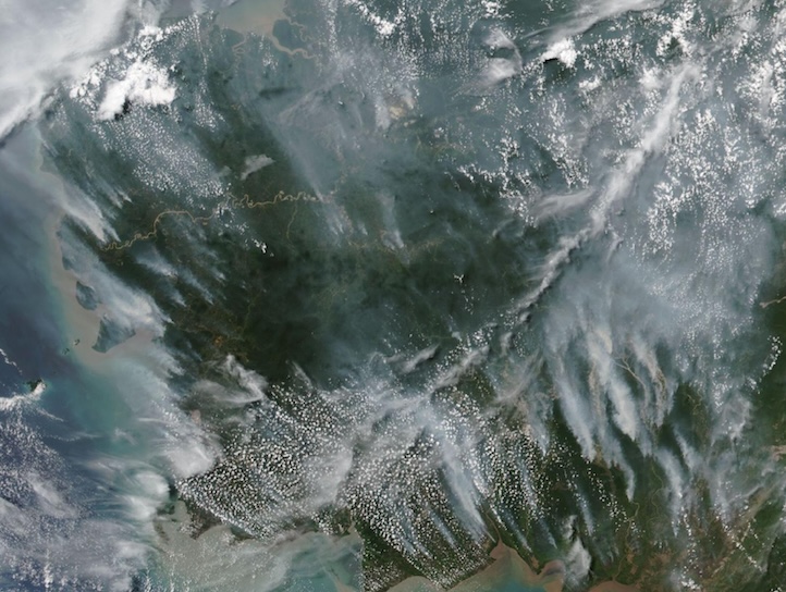
NASA Earthdata’s Worldview Image of the Week, published 31 August 2026, documents wildland fires across Indonesia — Sumatra, Kalimantan, Sulawesi, Java, and Papua — with poor air quality nationwide. The featured scene is from the Visible Infrared Imaging Radiometer Suite (VIIRS) on NOAA-20, acquired 28 August 2026 over Central and Western Kalimantan: gray smoke plumes blowing northwest, paired with VIIRS active-fire/thermal anomalies and an aerosol-index overlay showing high aerosol in orange/red.
Key facts
- Published
- Aug 31, 2026 — Worldview Image of the Week
- Sensor / time
- VIIRS on NOAA-20; imagery acquired Aug 28, 2026
- Place
- Central and Western Kalimantan, Borneo, Indonesia; fires also noted on Sumatra, Sulawesi, Java, Papua
- Smoke
- Gray plumes blowing northwest; aerosol index high in orange/red on official overlay
- Products
- VIIRS active-fire/thermal anomalies + aerosol index pair (official Earthdata page)
Fires in Central and Western Kalimantan left the island of Borneo shrouded in smoke on August 28, 2026.
NASA Earthdata Worldview Image of the Week, Aug 31, 2026
Note
The Earthdata page states wildfires are burning across Indonesia and causing poor air quality across the country. Smoky, aerosol-laden air can cause respiratory problems for people in the region — language from the official caption, not an invented health statistic.
Referenced datasets include the VIIRS NOAA-20 (JPSS-1) 375 m I-Band Active Fire Product NRT. Visit Worldview for near-real-time and historical imagery from NASA ESDIS.
Why it matters
Official Aug 31 NASA/NOAA-20 fire-and-smoke package for Kalimantan — a sourced Earth-systems air-quality signal with a figure, not a social-media smoke claim.
Sources
Official data. Not a forecast.