
official data (NOAA / NHC Public Advisory 25 + Discussion 25 + Forecast/Advisory 25, 2100 UTC / 200 PM MST Sat Sep 26 2026) · supersedes boarded Adv 23/23A card
Polo turns northwest at Cat 4 — NHC forecasts a Baja California Sur approach Monday
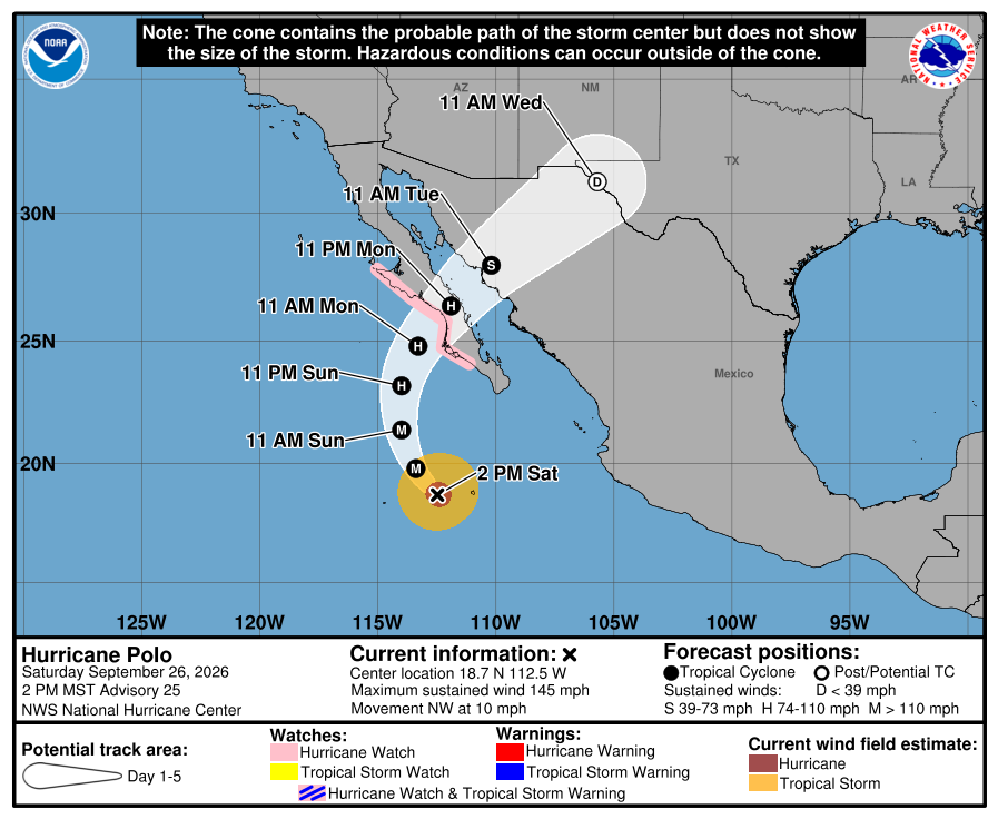
NOAA’s National Hurricane Center Advisory 25 at 2100 UTC on September 26 has Hurricane Polo turning northwestward as a Category 4 at 145 mph and 938 mb, about 335 miles south-southwest of Cabo San Lucas, and now says it is forecast to approach Baja California Sur on Monday — while Discussion 25 flags an unusually large spread in the track models, with some forecasting the hurricane to stall offshore, and calls confidence in the track “not particularly high.” The Hurricane Watch from Punta Eugenia to Santa Fe stays up.
Key facts
- Adv 25 live stamp (2100 UTC / 200 PM MST Sat)
- Cat 4 · 145 mph (230 km/h) · 938 mb · 18.7N 112.5W · NW (320°) at 10 mph · ~335 mi SSW Cabo San Lucas · ~420 mi S Cabo San Lazaro
- Headlines (Adv 25)
- POLO TURNS NORTHWESTWARD AS A POWERFUL HURRICANE · FORECAST TO APPROACH BAJA CALIFORNIA SUR ON MONDAY
- Forecast track (Adv 25)
- North Sunday, turn northeast Monday; on the forecast track, approaches the west coast of Baja California Sur Monday, crosses the peninsula Monday night, approaches NW mainland Mexico by early Tuesday
- Track confidence (Discussion 25)
- Unusually large spread in track models, mainly forward speed; AI guidance faster than many dynamical models; some hurricane regional models stall Polo offshore of the Baja peninsula’s west coast; NHC leans toward the AI models and HCCA — confidence “not particularly high”
- Discussion 25 intensity
- 125 kt; estimates range from 105 kt (SAR) to over 140 kt (ADT); inner core expanded, possibly an eyewall replacement cycle; easterly shear 10–15 kt; steady weakening forecast, still a strong hurricane approaching Baja California Sur; Hurricane Hunter flight scheduled
- Watch
- Hurricane Watch Punta Eugenia to Santa Fe (no change this advisory); watches likely for the east coast of the Baja peninsula later today; NW mainland Mexico watches may be required tonight or early Sunday
- Wind timing
- Hurricane conditions possible in the watch area by Monday afternoon; tropical-storm conditions possible in the southern portion Sunday night into early Monday, spreading north Monday
- Wind field (Adv 25)
- Hurricane-force winds extend up to 40 mi; tropical-storm-force up to 125 mi
- Rainfall
- 4–8 in (max 10) across portions of Baja California Sur — life-threatening flooding and mudslides possible
- Surge / surf
- Surge could bring significant coastal flooding with onshore winds; life-threatening surf and rip currents along west-central Mexico and the Baja peninsula through the weekend
- Delta vs Adv 23/23A
- Cat 5 · 165→160 mph · 917→922 mb · “expected to make landfall” → Cat 4 · 145 mph · 938 mb · “forecast to approach” Baja California Sur Monday
- Supersedes
- Morning Adv 23/23A Cat 5 card — off the board; page stays live in the archive
- Live later
- Intermediate 25A (500 PM MST) · next complete advisory (800 PM MST) · recon fix · east-Baja / NW mainland watches → HUD — no invented landfall hour or death toll
…FORECAST TO APPROACH BAJA CALIFORNIA SUR ON MONDAY…
NHC Public Advisory Number 25 · 200 PM MST Sat Sep 26 2026 · 145 mph / 938 mb
Note
National Hurricane Center Advisory 25, issued for 200 PM MST on September 26, has Hurricane Polo turning northwestward as a powerful hurricane. Sustained winds 145 mph, pressure 938 millibars, center near 18.7 north, 112.5 west — about 335 miles south-southwest of Cabo San Lucas — moving northwest at 10 mph. The headline now says Polo is forecast to approach Baja California Sur on Monday. On the forecast track it turns north Sunday and northeast Monday, approaches the west coast of Baja California Sur Monday, crosses the peninsula Monday night and approaches northwestern mainland Mexico by early Tuesday.
Discussion 25 sets intensity at 125 knots, with estimates ranging from 105 knots on a morning radar-satellite pass to over 140 knots from the automated Dvorak technique, and says an expanded inner core — possibly an eyewall replacement cycle — and 10 to 15 knots of easterly shear are likely weakening the storm. It flags an unusually large spread in the track models, mostly on forward speed: AI guidance runs notably faster than many dynamical models, and some hurricane regional models forecast Polo to stall offshore of the peninsula’s west coast. NHC kept its track leaning toward the AI models and consensus, and says confidence in that forecast is not particularly high. It still expects a strong hurricane when Polo approaches Baja California Sur.
The Hurricane Watch from Punta Eugenia to Santa Fe is unchanged; watches are likely for the east coast of the Baja peninsula later today, and northwestern mainland Mexico may need watches tonight or early Sunday. Hurricane conditions are possible in the watch area by Monday afternoon, with tropical-storm conditions possible in the southern portion Sunday night into early Monday. Rainfall of 4 to 8 inches, isolated 10, is forecast for portions of Baja California Sur, with life-threatening flooding and mudslides possible. This supersedes the morning Adv 23 Cat 5 card, which stays live in the archive. The Hurricane Hunter fix and the next advisories go to the HUD.
Why it matters
A Category 4 hurricane is still aimed at the Baja peninsula for Monday — but the National Hurricane Center’s own track confidence is thin, with some models parking Polo offshore. The bulletin dropped the landfall word this afternoon; the watch, the rain and the Monday window did not. Official product, not a death count.
Sources
- NOAA National Hurricane Center
- NHC Discussion 25
- NHC Forecast/Advisory 25
- NHC live Public (TCPEP2)
- NHC EP172026 archive
- NHC graphics (5-day cone)
- Superseded Adv 23 card (archive)
- Prior Adv 14 card
Primary + secondary attribution as listed. Live values go to the HUD / source product.